Wednesday, November 30, 2005

CONCENTRATING AND REDISTRIBUTING AGENCY


As an strategy to build a supporting network, I am inviting relevant actors to know our Cordillera to invite them to put our territory in their agenda. In this way, I am realizing that the problem of Cordillera was "an agency problem", I see la Cordillera as a big boundary object, plenty of little boundary objects... even I am discovering places where no body knows the owner... for example... who is the owner of the rights of use of water in Natural Sanctuary? who is responsible of maintaining the old road? who should get rid off the snow in winter? someone say... el ministerio, la municipalidad, un dia hubo un dueño...

When our institution elected me as Director, in some way they decided to concentrate all those forgotten agencies in one and only head. However, through all this diagnosis period, I realized that it could be a deep mistake to concentrate the agencia of local sustainable development of such a multi-stakeholder territory in just one institution. That´s why my focus is on concentrating my efforts in facilitating and involving all related stakeholders, re-distributing the agency, inviting actual local actors and other potential experienced and powerful actors that will connect our projects with other local and global networks... for example, aiesec, basque government, eurochile.cl, Unesco, argentinan national parks... I am learning a lot about concentrating and re-distributing agency.

Best regards from the andean summits!

Tuesday, November 29, 2005

EL PLOMO (5.424 m)


Best Season
Between November and March. In spring the approach to the Plomo´s base will have plenty of snow. The best time is between January and March, when there is no snow during the approach and the weather is more stable.

Access Via Valle Nevado
Going up Av. Las Condes, take the road to Farellones. At the end of the curves and just before reaching Farellones (it is 48 kms. up to here), turn right towards the Valle Nevado Ski Center. From the ski center, and after obtaining permission to pass through its land, take the dirt road that will get you through the ski runs and closest to Cerro Tres Puntas, East of the area called Tierras Bayas (3.450 mts). This is where the approach by foot starts. The trail is very wide and clear and descends quickly into the ravine ahead. In total, from the beginning of the road to Farellones up to Tres Puntas, it is more or less 2 hours by car. From Tres Puntas to the first campsite, Piedra Numerada, it takes between 1 and 2 hours walking. Piedra Numerada is at 3.370 meters above sea level.

Via La Parva
Taking the same road to Farellones, continue past Farellones (do not turn right at the turn to Valle Nevado) to the La Parva Ski Center. Continue, if possible, to the ski center´s highest point, depending on whether the road up the ski runs is open and clear of snow (ask local workers to show the way). Via this road you will reach the end of the last lift, called Piuquenes, right next to the pass between Cerros Franciscano and Falsa Parva. From the beginning of the road to Farellones up to Piuquenes, it takes between one hour and one hour and a half by car. From Piuquenes to Piedra Numerada, it takes between two and two and a half hours walking. If the road up the ski runs isn´t open, consider 2 or 3 hours of heavy hiking from the ski center to the pass (if there is no snow), which is at 3.470 meters above sea level.


Approach
Piedra Numerada (3.370m) is the natural place for sleeping the first night. In the middle of a great vega (plain covered with high altitude vegetation and with abundant water), right next to the Cepo River, Piedra Numerada was used for many years by the arrieros to count the animals before taking them down to the valley just before winter arrived. It is a spacious place, with plenty of water and lots of room for setting up camp. Some boulders and stone parapets are a reference point. Beware of mice: do not leave food or garbage at their reach.

The Climb Piedra Numerada-La Hoya
The trail from Piedra Numerada to La Hoya follows the stream most of the time and it climbs above and to the right of the waterfall visible from Piedra Numerada. In more or less 4 hours, one should reach La Hoya, though this will depend greatly on the physical condition and acclimatization of each climber See Foto5 . La Hoya (4200m)La Hoya is reached just after going up a grey mound that is visible from an orange shelter (Refugio Federación, houses 4 people comfortably) located at a side of the trail which heads in Plomo´s direction. The site of the orange shelter is an alternative campsite. A better rest (with less "puna", or altitude sickness) can be obtained here, which may compensate the extra effort during the summit day. This place is at approximately 4100 mts.La Hoya is a sandy place very near the Iver Glacier´s moraine. It is a place somewhat protected from the wind, but is is also very common to get "puna" or high altitude sickness here, more than in other places as high. Other possible campsites are "Los Espejos" and the "Refugio de Agostini". The first is at aproximately 15-20 minutes from La Hoya following the trail that leads to the summit. Just in the middle of a section covered with stones and boulders, there are two little ponds of pristine waters The place is fine for setting up camp, since it is protected from the wind, it is less crowded than La Hoya and, according to some isolated studies, it is somewhat less "puna" prone. The "Refugio de Agostini" is a modest but efficient wooden shelter at the foot of the Plomo´s main scree slope. It was built by the Federación de Andinismo in the sixties and today isn´t in a very good state See Foto2 . Built at 4.600 meters, the Refugio de Agostini is very exposed to the wind, and has no water near it, though there is snow for melting. The shack allows for a low three person tent to be set up inside. The choice of which of these places to choose for resting before the summit bid is crucial. The extra work that carrying all the gear and food up to the Refugio de Agostini isn´t always compensated with an equivalent saving during the final ascent; this will depend largely on each climber´s capacity. With heavy loads, from La Hoya to the Refugio might take more than and hour and a half. The same distance is covered in half the time during a normal summit bid. For those who enjoy socializing, we recommend La Hoya. For those who would rather be alone, Los Espejos will suit them better. Climbers on a training program should go up to the Refugio. For those very "puna" prone, we recommend staying below La Hoya, at the Refugio Federación.

La Hoya-Summit
From La Hoya turn back towards the valley and then follow the trail that overcomes the promontory that guards La Hoya from the South, turning again towards Plomo. The trail goes East up to Los Espejos, where it turns North, towards the Iver Glacier, thus circling La Hoya, which is always visible from up high. Later, the plateau where the Refugio de Agostini lies is reached. At this point (good place for resting and hydrating) a very long scree slope starts. Several winding trails reach some rock turretsby different paths, visible from everywhere; these mark the end of the scree. The most common way up from here (less steep and on firmer ground) is to circle these rocks from the East (going opposite to Cerro Plomo; to the right). Then comes a traverse just above the Iver Glacier, along a trail over big rocks. This traverse ends at Plomo´s summit ridge. A few more minutes and the upper crossing of the glacier is reached. Just above a stone dome there is a stone parapet which protects from the wind and serves as a resting placing before crossing the glacier ("Pirca del Inca", 5050m. Here Plomo´s Mummy was found); from here the mountain´s northern glaciers become visible and for the first time is one convinced that the Leonera was left below. The glacier´s crossing has a gentle incline and is free of crevasses. (The crossing takes between 15 - 30 minutes on a normal year at its narrowest part) See Foto3 .

However, the ice may be hard, making the use of crampons and extreme care necessary: it takes but a few meters sliding to reach the point where the gradient changes violently, exposing one to a 600 meter fall. Once the glacier crossed, it takes less than an hour to reach the summit.The summitFrom La Hoya it takes between 4 and 8 hours to reach the summit, varying widely with the weather conditions and the climber´s fitness. A good reference is six hours from La Hoya. The way down takes approximately half the time of the ascent. This classical central zone mountain´s summit is a fine spectacle: from it, all the high summits of the central zone are visible, from Mercedario in the North, to Volcán Maipo in the South; the view thus covers nearly 300 kms. See Foto4 . The summit is broad, and it takes a few minutes to cross up to its highest point, marked by a cross and memorial to the fallen climber of the first Chilean expedition to Mount Everest, Víctor Trujillo. The summit is normally whipped by the Boreas (north wind), and the wind chill makes one feel very cold, unless adecuate protecion against the wind is used.


Recommendations :
Take good gear
Hydrate continuously
The summit bid should start very early (6 am at the very latest). This because in summer it is very common for clouds to cover the mountain by midday, with fair chances of an electrical storm or snowfall. Therefore it is recommended to reach the summit not later than noon. The Plomo´s summit isn´t a safe place to be. Shoes and clothing suited for high altitude mountaineering.
Crampons, needed when the upper glacier is hard.
Ice axe
Trekking poles (optional)

Friday, November 25, 2005

NATURAL SANCTUARY OF YERBA LOCA


Located in the cordilleran landscape of the Central Andes, the Nature Sanctuary of ‘Yerba Loca’ is an excellent option to enjoy an evening or a weekend amidst the quietness and beauty offered by nature.


Given the characteristics of the reserve, it is possible to carry out several activities there: trekking, mountaineering, ice climbing, horseback riding, observing flora and fauna and picnics.
Being 25 kilometers away from Santiago, to get to the reserve you have to take the road leading to Farellones, in the 15th switchback (they are numbered) you will find the park ranger station of the sanctuary, run by CONAF (National Forestry Corporation). Here you will get basic information and recommendations for the visitor.

Passing the administration sector, there are four kilometers of a dirt road in regular condition this is the way to get to the place known as ‘Villa Paulina’. At this place, there are camping sites, primary facilities and picnic places equipped with tables, benches, trash bins, furnaces and parking places.

The visitor can visit the area from this place.
Something to know...
With a surface of 39 thousand hectares, from which 11 thousand and 575 are run by CONAF, this protected area has several interesting sites, being Villa Paulina, Piedra Carvajal and La Paloma and El Altar glaciers the most remarkable ones.
To visit the reserve safely and ecologically, you just have to go along the paths marked out by CONAF. The most interesting is the one leading to La Paloma and El Altar glaciers through Villa Paulina. It is a 14-kilometer way through the valley of Yerba Loca creek. Along the way, you can see the range limiting the hydrographic river basin, or the range El Plomo – La Parva to the east and Yerba Loca to the west.

The mounts of La Paloma, Falso Altar and El Altar (5,222 meters above sea level), located at the end of the valley, can be seen during our walk, but don’t get confused, El Altar mount can be seen only from Piedra Carvajal sector; the one in front of you along the way is is the Falso Altar.
The path follows the main water stream, called ‘Yerba Loca’, whose origin is located at 3,900 meters above sea level, at the foothills of ‘La Paloma’. Its waters contain a great amount of sulfates that not only give the water a turquoise color, but also make it not suitable to drink.
Its affluents are the brooks La Leonera and Chorrillo del Plomo, apart from the numberless springs flowing near the main stream, which not only add water, but also produce many waterfalls.

Protection. The main goal...
Since the fact that Yerba Loca is located about 900 and 5,500 meters above sea level, the variety of flora is very rich (in fact, the sanctuary’s name belongs to a herb widely spread in the area). Up to 1,300 meters above sea level, there are some arboreal species such as bollen, litre, quillay and lun.

Between 1,300 and 2,000 meters above sea level, the olivillo of the cordillera is very common, though it is an endangered species in the Metropolitan Region. Apart from this, in Villa Paulina sector, there are small forests of foreign species (by inhabitants of this area as well as by CONAF), which have adapted to the Andean sector conditions. They comprise certain coniferous such as the cypresses, pines (oregon), poplars, elms and eucalyptus.
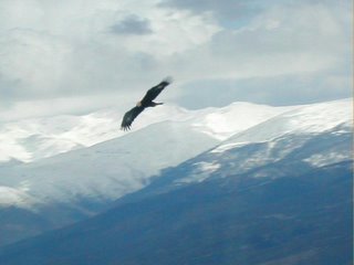
Doubtless, the presence of birds in the sanctuary is predominant. The most common species are the turtledoves (Zenaida Auriculata), and Peuco (Parabuteo unicinctus) and kestrels among the birds of prey. At a higher altitude, eagles and condors dominate the skies.
The rest of the representatives of the animal kingdom, among mammals and reptiles, is not so abundant. The family of mammals with the biggest number of inhabitants is the rodents, being the representative species the cururo, the degu (Octodon degus) and Darwin’s long-eared mouse. Although is not uncommon to see gray foxes (Dusycion Griseus) around.

Having fun
The best time to visit Yerba Loca elapses between the months of December to March. In the sector of Villa Paulina, it is very hot, but the heat decreases while you go up; nevertheless, the dangerous effects of the sun don’t decrease at all.
What to do? Walking along the paths of the sanctuary, enjoying the exercise and the landscape seems to be the most common and relaxing choice. Another possibility is hiring horses and riding along the paths. It may be fun, amusing and relaxing.

On the other hand, mountaineering lovers consider the mounts of La Paloma and El Altar as interesting goals, not only to get to their summits, but also to climb their hanging glaciers.
If it is true that the best time to visit the sanctuary is during spring time, fall and winter also has their charm. For all those who like snowy landscapes, snow can even cover the road into the park (and even farther), and the mean low temperatures may fall well below freezing, being the park closes when it is impossible to walk around.
What to take...


If you visit the sanctuary during summer time, don’t forget to take a good sun block lotion, SPF 30 minimum, light clothes, shoes adequate to walk along dirt and sometimes rugged paths.
Enough food and water (you can take it from several springs, but avoid the main stream), cap and sunglasses to protect you from the sun, and warm clothes for the evenings or at higher altitudes.
If the visit is in winter, or at the end of it, take everything mentioned above, varying perhaps the shoes, which must be adequate to walk in the snow, and also bring a gloves and a parka.

Text: G. Salinas
http://www.gochile.cl/html/YerbaLoca/yerbaloca.asp
Wednesday, November 23, 2005

Minimum Impact in El Plomo

El Plomo is one of the favourite mountains for andinists, due to its accessibility, and for many Chilean mountaineers, the first five-thousand-summitt in their lives. More than one thousand people climbs El Plomo each summer season. Many expeditions prefer to climb it before the Aconcagua, because this helps them to acclimate better to the next step. Even several Adventure-tourism companies sell the combo-pack: Plomo + Aconcagua in three weeks.
Unfortunately, until now, there are no control systems nor environmental management of all this increasing demand.

That's why we invited to the relevant stakeholders to get involved in a minimum impact committee, in order to explore and manage an action plan to manage all the waste generated, involving each community member.

We are learning from international experiences, such as Aconcagua, the nearest one.
Our first meeting was three weeks ago. The mere fact of sitting around a table, is already an advance in this fragmented environment. Next week, we will have the following meeting, and we will arrange the visit of some experts in ecological W.C. with bio-filters (lumbricultura) ...

if you are interested... keep on reading cordilleractiva.blogspot.com

See the international experiences at:
http://www.aconcagua.com.ar/controlderesiduos.asp

Wednesday, November 16, 2005

Primer Hito Superado

El pasado 15 de octubre, se sentó un significativo precedente en la Gestión de la Cordillera.
Por primera vez, se presentó al Concejo Municipal un diagnóstico global e integral de todas las problemáticas, oportunidades y desafíos presentes en el Territorio Cordillerano.
Por vez primera se mostraron cifras de cuánto gasta la municipalidad allá arriba y cuánto genera de ingreso. Por vez primera se visualizó el territorio no como un cacho sino como una unidad de negocio, con indicadores que se pueden y deben gestionar.

Y lo más importante, por primera vez, la Cordillera tendrá un item presupuestario, que si bien es insuficiente frente a lo ilimitado de las necesidades, sienta un precedente, que seguramente irá aumentando progresiva y paulatinamente con el tiempo.

Felicidades.

Monday, November 14, 2005

We do not inherit the earth from our ancestors, we borrow it from our children

This contribution is dedicated to the “Inka boy”

In order to march towards sustainability and a better balance with our own environment we must, first of all, define what does this mean and who is involved on the endeavour. How and why is this beneficial and who is benefiting?

For many of us, sustainable development is self-evident as something good, and therefore we are already motivated to work for it. However, this is not always the case and we tend to focus on imitating strategies that we saw working somewhere else, rather than working on our particularities and on an authentic manner.

This question is more important because it is the only way to articulate different people/organisations and the environment around the same project. So, why is sustainability important for us and how can we achieve it? In which degree can we be a sustainable community? How are we defining sustainability?

When we carry our daily routines we normally do not see all that they involve, nor all the entities that they call into action. For instance, when I turn on my computer to write these lines I am not aware, for example, of where the power to run my computer comes from – does it come from a sustainable source or from a nuclear power station? I am not aware if there was child labour involved on the making of my computer, nor on the making of the turbine on the nuclear power station that provides the power to run my computer. In short, we can never know all the references and entities that are aligned to make our daily routines possible as they are. Is there any relationship between the petrol used on the power station, to produce the power to run my computer and the last person killed in the middle-east? How my daily routine does relates to all this things? I guess that we will never now this for sure.

So, what is our sustainability about? Is it about energetic independence? Is it about easing the effect of our daily life on the other living beings on our environment? Do we want that our life style affect the Mapocho river? Or are we more concern with the possibility that other people’s life style affect our own quality of life? Or are we so altruistic that we only care about the future generations to come?

According to a Native American proverb: “We do not inherit the earth from our ancestors, we borrow it from our children.” Therefore, I thank all the Inka boys from the past, for allowing the earth that they borrowed from us to be ready for us to enjoy it now.

When we regard our relationship with our environment from this perspective we start caring about the consequences of our daily life. Right? Why should we import and burn oil? Why should we leave to nature the task of taking care of our garbage? Alone we are unable to live on a sustainable manner, but on a collaborative manner we can do a lot. It is up to us to decide the world we want to live on.

Wednesday, November 02, 2005

THE MYSTERY OF THE INKA BOY


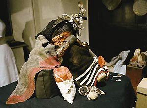
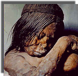
Five hundred years ago, an inka boy was sacrified in the summit of El Plomo Mountain (5.480 m.), in Central Andes. He was just eight years old. He became into an offer to the gods of the mountain. He was probably an inka prince, or a son of some aristrocratic member of inka society. He was taken in a long walking journey by inka priests. They combed his hair into "trencitas". He wore guanaco leather clothes and a bag with some sacred idols.

Fifty four years ago, some treasure-hunters found his body, almost untouched, due to cold temperatures. It had been kept liofilized for centuries. They found some yerba de coca into his teeth.

Some scientificians say that he may be alive when he was founded, in some kind of "suspended animation state". Probably, we will never know the truth.
Some researchers of Chilean University, scanned the body and found an interesting paleo-infection in the body. Nowadays, our inka boy rests on a dark, cold specially taylor-made crypt in the basement of Natural History National Museum.


What should we do with this heritage? Should we keep as a secret? Should we transform it into a touristic attraction? Should we publish some new book about him?